Geomorphologists who study Earth’s surface features and the processes that formed them have long been interested in how floods, in particular catastrophic outbursts that occur when a glacial lake ice dam bursts, for example, can change a planet’s surface, not only on Earth but on Mars. Now geoscience researchers Isaac Larsen at the University of Massachusetts Amherst and Michael Lamb at the California Institute of Technology have proposed and tested a new model of canyon-forming floods which suggests that deep canyons can be formed in bedrock by significantly less water than previously thought.
Geomorphologists who study Earth’s surface features and the processes that formed them have long been interested in how floods, in particular catastrophic outbursts that occur when a glacial lake ice dam bursts, for example, can change a planet’s surface, not only on Earth but on Mars.
Now geoscience researchers Isaac Larsen at the University of Massachusetts Amherst and Michael Lamb at the California Institute of Technology have proposed and tested a new model of canyon-forming floods which suggests that deep canyons can be formed in bedrock by significantly less water than previously thought. They point out that “reconstructing the magnitude of the canyon-forming floods is essential for understanding how floods modify planetary surfaces, the hydrology of early Mars, and abrupt climate change.”
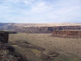
Larsen and Lamb apply their new model to the “channeled scablands” in eastern Washington State, an area that, like some on Mars, has very deep canyons cut into fractured basalt bedrock. The researchers say their results suggest “there may be a rich imprint of both the history and discharge of flooding in the morphology of canyons” such as terraces, valley shapes and slope profiles on Earth and on Mars “that warrant further investigation.” Details appear in the current issue of Nature.
The researchers say channels in the scablands today, which are up to 650 feet (200 meters) deep and 3 miles (5 km) wide, were likely formed by flood discharges five- to tenfold smaller than brimful estimates, that is by “significantly lower megaflood discharges than previously thought. The channeled scablands are a classic landscape in the history of geomorphology and we’re bringing new views of how it was formed.”
Until the 1920s, scientists did not understand what could have formed the tortured landscape of eastern Washington studied for decades by J Harlen Bretz, a giant figure in geosciences, Larsen recalls. Bretz was the first to suggest that they were formed by catastrophic flooding of unknown origin. His views were dismissed for years, but Bretz was later vindicated when glacial Lake Missoula was identified as the floodwater source.
Continue reading at UMass Amherst.
Image via UMass Amherst.


