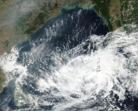
An area of tropical low pressure designated System 99B has consolidated and developed into Tropical Cyclone 05B. On Dec. 7 the Visible Infrared Imaging Radiometer Suite (VIIRS) instrument aboard the NASA-NOAA Suomi NPP satellite captured a visible image of Tropical Cyclone 05B over the Anadaman and Nicobar Islands. The VIIRS image showed bands of thunderstorms wrapping around the center from the northern to the eastern quadrants over the Anadaman Islands.
An area of tropical low pressure designated System 99B has consolidated and developed into Tropical Cyclone 05B. On Dec. 7 the Visible Infrared Imaging Radiometer Suite (VIIRS) instrument aboard the NASA-NOAA Suomi NPP satellite captured a visible image of Tropical Cyclone 05B over the Anadaman and Nicobar Islands. The VIIRS image showed bands of thunderstorms wrapping around the center from the northern to the eastern quadrants over the Anadaman Islands.
The Joint Typhoon Warning Center or JTWC issued the first bulletin on the storm at 10 a.m. EST (1500 UTC) when Tropical Cyclone 05B had maximum sustained winds near 40 mph (35 knots/62 kph). 05B was located near 10.9 degrees north latitude and 91.7 degrees north longitude, about 696 nautical miles south of Chittagong, India.
Continue reading at NASA / Goddard Space Flight Center
Photo Credit: NASA / NOAA / Goddard Rapid Response Team


