Surfers aren’t the only people trying to catch big waves. Scientists at the Department of Energy’s Lawrence Berkeley National Laboratory (Berkeley Lab) are trying to do so, too, at least in wave climate forecasts.
Surfers aren’t the only people trying to catch big waves. Scientists at the Department of Energy’s Lawrence Berkeley National Laboratory (Berkeley Lab) are trying to do so, too, at least in wave climate forecasts.
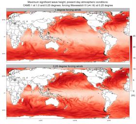
Using decades of global climate data generated at a spatial resolution of about 25 kilometers squared, researchers were able to capture the formation of tropical cyclones, also referred to as hurricanes and typhoons, and the extreme waves that they generate. Those same models, when run at resolutions of about 100 kilometers, missed the tropical cyclones and the big waves up to 30 meters high.
Their findings, to be published in the Feb. 16 issue of Geophysical Research Letters, demonstrate the importance of running climate models at higher resolution. Better predictions of how often extreme waves will hit are important for coastal cities, the military, and industries that rely upon shipping and offshore oil platforms. And, of course, for surfers.
“It’s well known that to study tropical cyclones using simulations, the models need to be run at high resolution,” said study lead author and postdoctoral fellow Ben Timmermans. “The majority of existing models used to study the global climate are run at resolutions that are insufficient to predict tropical cyclones. The simulations in our study are the first long-duration global data sets to use a resolution of 25 kilometers. It’s also the first time a study has specifically examined the impact of resolution increase for ocean waves at a global climatological scale.”
Read more at Lawrence Berkeley National Laboratory
Photo credit: Ben Timmermans/Berkeley Lab


