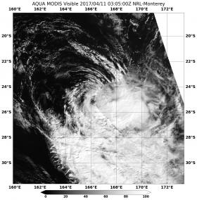
NASA's Aqua satellite observed how strong wind shear was literally pushing Tropical Cyclone Cook apart as it displaced the bulk of clouds to the southeast of the center.
NASA's Aqua satellite passed over Cook on April 11 at 0305 UTC (11:05 p.m. EST) and captured a visible and infrared image of the storm. The Moderate Resolution Imaging Spectroradiometer or MODIS instrument took a visible image of the storm. The image showed that strong vertical wind shear had pushed the bulk of clouds and thunderstorms southeast of the center of circulation.
The Joint Typhoon Warning Center or JTWC noted at 10 a.m. EST (1500 UTC) that Cook's maximum sustained winds were near 45 knots (52 mph/83 kph). The storm was weakening as it transitioned into an extra-tropical cyclone. It was about 490 nautical miles south of Noumea, New Caledonia, near 27.0 degrees south latitude and 168.6 degrees east longitude. Cook was moving to the southeast at 13 knots (15 mph/24.8 kph).
Read more at NASA / Goddard Space Flight Center
Image: NASA's Aqua satellite passed over Tropical Cyclone Cook on April 11 at 0305 UTC (11:05 p.m. EST) and saw strong vertical wind shear had pushed the bulk of clouds and thunderstorms southeast of the center of circulation. (Credits: NASA / NRL)


