The ninth tropical depression of the Northwestern Pacific Ocean has formed and developed into a tropical storm. Tropical Storm Kulap was spotted by NASA’s Terra satellite far to the west of Midway Island.
The ninth tropical depression of the Northwestern Pacific Ocean has formed and developed into a tropical storm. Tropical Storm Kulap was spotted by NASA’s Terra satellite far to the west of Midway Island.
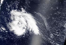
On July 20 at 1:30 p.m. EDT, the Moderate Resolution Imaging Spectroradiometer, or MODIS, instrument aboard NASA’s Terra satellite captured a visible light image of Tropical Storm Kulap. The visible MODIS image showed a large band of thunderstorms northeast and southwest of the low-level center. The visible imagery shows the largest area of thunderstorms southwest of the center. Animated enhanced infrared satellite imagery also showed an area of elongated deep convection with the center located along the southwest edge of the deep convection.
Read more at NASA / Goddard Space Flight Center
Image: On July 20, 2017, at 1:30 p.m. EDT, NASA's Terra satellite captured this visible light image of Tropical Storm Kulap in the Northwestern Pacific Ocean. Credits: NASA Goddard MODIS Rapid Response Team.


