Tropical Cyclone Ockhi is quickly weakening in the Arabian Sea and is expected to dissipate on Dec. 6 when it makes landfall in northwestern India. The Global Precipitation Measurement mission or GPM core satellite passed over Ockhi and looked at its rainfall as wind shear was affecting the storm.
Tropical Cyclone Ockhi is quickly weakening in the Arabian Sea and is expected to dissipate on Dec. 6 when it makes landfall in northwestern India. The Global Precipitation Measurement mission or GPM core satellite passed over Ockhi and looked at its rainfall as wind shear was affecting the storm.
On Dec. 2, Ockhi became the first tropical cyclone of the year to form in the Arabian Sea. Fortunately for India the tropical cyclone remained off India's southwestern coast. Ockhi intensified to the equivalent of a category 3 hurricane on the Saffir-Simpson hurricane wind scale before it started to weaken. Vertical wind shear caused Ockhi to weaken as the tropical cyclone started moving north-northeastward toward India's Gulf of Khambhat.
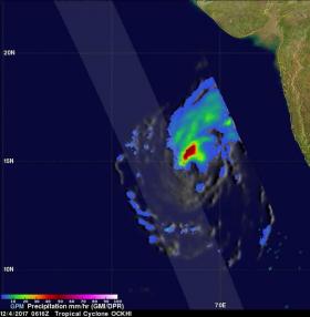
NASA's GPM Core Observatory satellite passed over Tropical Cyclone Ockhi on Dec. 4 at 1:16 a.m. EST (0616 UTC). GPM is a joint mission between NASA and the Japanese space agency JAXA.
The rainfall coverage was derived from data collected by GPM's Microwave Imager (GMI) and Dual-Frequency Precipitation Radar (DPR) instruments. Those data showed that very heavy rainfall was being produced by powerful storms northwest of Ockhi's eye. Wind shear was already pushing the strongest storms away from the center of circulation.
Read more at NASA/Goddard Space Flight Center
Image: On Dec. 4, GPM found rain falling at a rate of over 62 mm (2.44 inches) per hour in storms northeast of the center. On the western side storms rainfall was occurring at a rate of over 60 mm (2.27 inches) per hour. (Credits: NASA/JAXA, Hal Pierce)


