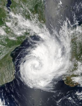
On Feb. 14, 2017 at 2:45 a.m. EST (0745 UTC) the Moderate Resolution Imaging Spectroradiometer or MODIS instrument aboard NASA's Terra satellite captured a visible image Dineo that showed strong thunderstorms wrapping into and around the "heart" or center of the storm's low-level circulation. A thick band of powerful thunderstorms from the eastern quadrant wrapped south and west into the center.
On Feb. 14, 2017 at 2:45 a.m. EST (0745 UTC) the Moderate Resolution Imaging Spectroradiometer or MODIS instrument aboard NASA's Terra satellite captured a visible image Dineo that showed strong thunderstorms wrapping into and around the "heart" or center of the storm's low-level circulation. A thick band of powerful thunderstorms from the eastern quadrant wrapped south and west into the center.
The Mozambique Channel is the body of water bordered by the island nation of Madagascar to the east and Mozambique on the mainland African continent on the west.
On Feb. 14 at 10 a.m. EST (1500 UTC), Dineo had maximum sustained winds near 63 mph (55 knots/102 kph). Dineo's winds are expected to reach hurricane strength later today, February 14, and peak near 75 knots by 7 a.m. EST (1200 UTC) on February 15.
Read more at NASA
Image Credits: NASA


