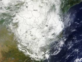
Late on Feb. 15, Dineo made landfall in southern Mozambique. By Feb. 17 the storm weakened to a remnant low pressure area when NASA's Terra satellite passed overhead. The Moderate Resolution Imaging Spectroradiometer or MODIS instrument aboard Terra captured a visible image that showed the center of the low pressure area over Zimbabwe and clouds extended over found Dineo's clouds stretched over southern Mozambique, Swaziland, eastern Botswana and northeastern South Africa.
Late on Feb. 15, Dineo made landfall in southern Mozambique. By Feb. 17 the storm weakened to a remnant low pressure area when NASA's Terra satellite passed overhead. The Moderate Resolution Imaging Spectroradiometer or MODIS instrument aboard Terra captured a visible image that showed the center of the low pressure area over Zimbabwe and clouds extended over found Dineo's clouds stretched over southern Mozambique, Swaziland, eastern Botswana and northeastern South Africa.
The Global Precipitation Measurement mission or GPM core observatory satellite flew over Mozambique on February 16, 2016 at (4:16 a.m. EST) 0916 UTC after Dineo's maximum sustained winds had fallen to about 60 knots (69 mph) and the storm continued moving inland.
Data collected by GPM's Microwave Imager (GMI) and Dual-Frequency Precipitation Radar (DPR) instruments showed that the tropical cyclone was still dropping light to moderate rainfall over a large area of southern Mozambique. This GPM view revealed that some of the most intense rain bands from Dineo had moved over Swaziland and northeastern South Africa. GPM found that a few powerful storms over Swaziland were dropping precipitation at a rate of over 86 mm (3.4 inches) per hour.
Read more at NASA
Image Credits: NASA Goddard MODIS Rapid Response


