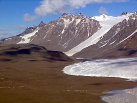
Researchers funded by the National Science Foundation (NSF) have publicly released high-resolution maps of Antarctica's McMurdo Dry Valleys, a globally unique polar desert.
The high-resolution maps cover 3,564 square kilometers of the McMurdo Dry Valleys and allow researchers to compare present-day conditions with lower-resolution LIDAR surveys conducted almost 13 years ago.
Scientists from Portland State University led the new research project, which mapped the area using more sophisticated LIDAR, a remote-sensing method that uses laser beam pulses to measure the distance from the detector to the Earth's surface.
Two NSF-funded facilities, the OpenTopography Facility and the Polar Geospatial Center, made the LIDAR data publicly available. A paper about the work was published in the journal Earth System Science Data.
The data, collected by aerial survey missions flown in the Southern Hemisphere in the summer of 2014-2015, provide detailed topography of the perpetually ice-free region, where surprising landscape changes, such as rapid erosion along some streams, have been observed in recent years.
Continue reading at National Science Foundation
Image: The Canada Glacier in the McMurdo Dry Valleys.
Credit: David Haney, NSF


