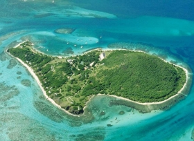
What is an Island? Land that is surrounded by water. Islands are always being created and sometimes destroyed. Earth has 657 more barrier islands than previously thought, according to a new global survey by researchers from Duke University and Meredith College. The researchers identified a total of 2,149 barrier islands worldwide using satellite images, topographical maps and navigational charts. The new total is significantly higher than the 1,492 islands identified in a 2001 survey conducted without the aid of publicly available satellite imagery. The 2,149 barrier islands measure 20,783 kilometers in length, are found along all continents except Antarctica and in all oceans, and make up roughly 10 percent of the Earth's continental shorelines. Seventy-four percent of the islands are found in the northern hemisphere.
What is an Island? Land that is surrounded by water. Islands are always being created and sometimes destroyed. Earth has 657 more barrier islands than previously thought, according to a new global survey by researchers from Duke University and Meredith College. The researchers identified a total of 2,149 barrier islands worldwide using satellite images, topographical maps and navigational charts. The new total is significantly higher than the 1,492 islands identified in a 2001 survey conducted without the aid of publicly available satellite imagery. The 2,149 barrier islands measure 20,783 kilometers in length, are found along all continents except Antarctica and in all oceans, and make up roughly 10 percent of the Earth's continental shorelines. Seventy-four percent of the islands are found in the northern hemisphere.
!ADVERTISEMENT!
Continental islands are bodies of land that lie on the continental shelf of a continent. Oceanic islands are ones that do not sit on continental shelves. The vast majority are volcanic in origin. The few oceanic islands that are not volcanic are tectonic in origin and arise where plate movements have lifted up the deep ocean floor to above the surface.
Their distribution is strongly related to sea level history in addition to the influence of tectonic setting. Rising sea level in the late Holocene (5000 years ago)is associated with the greatest island abundance, especially on North Atlantic and Arctic coastal plains.
Stable or falling sea level in the same time frame, a pattern typical of the Southern Hemisphere, is associated with a lower abundance of islands and a higher percentage of islands along deltas rather than coastal plains. Both coastal plain and delta type island morphology are sensitive to the wave action; however, island length is 40% greater along coastal plains whereas inlet width is 40% greater on deltas.
Island morphology is also fundamentally affected by climate. Island lengths in the Arctic are on average (5 km) only half the global average (10 km) because of the effect of sea ice on fetch and thus wave energy. Storm frequency in the high and middle latitudes is suggested to result in shorter and narrower islands relative to those on swell-dominated low-latitude coasts. The ratio of storm wave height to annual mean wave height is a good indicator of the degree of storm influence on island evolution.
The survey results appear in the current issue of the peer-reviewed Journal of Coastal Research.
"This provides proof that barrier islands exist in every climate and in every tide-wave combination," says Orrin H. Pilkey, James B. Duke Professor Emeritus of Geology at Duke's Nicholas School of the Environment. "We found that everywhere there is a flat piece of land next to the coast, a reasonable supply of sand, enough waves to move sand or sediment about, and a recent sea-level rise that caused a crooked shoreline, barrier islands exist."
Barrier islands often form as chains of long, low, narrow offshore deposits of sand and sediment, running parallel to a coast but separated from it by bays, estuaries or lagoons. Unlike stationary landforms, barrier islands build up, erode, migrate and rebuild over time in response to waves, tides, currents and other physical processes in the open ocean environment.
The 657 newly identified barrier islands didn't miraculously appear in the last decade, explains Matthew L. Stutz, assistant professor of geosciences at Meredith, located in Raleigh, N.C. They've long existed but were overlooked or misclassified in past surveys.
Previously, for instance, scientists believed barrier islands could not exist in locations with seasonal tides of more than about 13 feet. Yet Stutz and Pilkey's survey identifies the world's longest chain of barrier islands along a stretch of the equatorial coast of Brazil, where spring tides reach about 25 feet.
The 54-island chain extends about 400 miles along the fringe of a mangrove forest south of the mouth of the Amazon River. Past surveys did not recognize it as a barrier island coast partly because older, low-resolution satellite images did not show a clear separation between the islands and mangrove, Stutz says, but also because the chain didn't match the wave-tide criteria used to classify barrier islands in the United States, where most studies have been conducted. Scientists failed to consider that supplies of replenishing sand are so plentiful along the equatorial Brazilian coast that they can compensate for the erosion caused by higher spring tides.
For further information: http://www.jcronline.org/doi/full/10.2112/09-1190.1


