Tropical Storm Merbok formed in the South China Sea west of the Philippines on June 11 and made landfall east of Hong Kong, China on June 12. NASA measured the rainfall rates within the tropical storm early in its short two day lifetime.
Tropical Storm Merbok formed in the South China Sea west of the Philippines on June 11 and made landfall east of Hong Kong, China on June 12. NASA measured the rainfall rates within the tropical storm early in its short two day lifetime.
The Global Precipitation Measurement mission or GPM core observatory satellite flew above Merbok on June 10, 2017 at 0631 UTC (2:31 a.m. EDT) when the tropical storm was forming. GPM's Microwave Imager (GMI) and Dual-Frequency Precipitation Radar (DPR) showed that the future tropical storm was starting to get organized. Feeder bands were shown converging into the center of the circulation located in the South China Sea west of Luzon, Philippines.
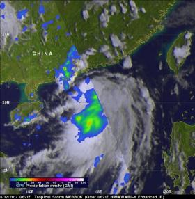
GPM passed over the western side of tropical storm Merbok again on June 12, 2017 at 0621 UTC when its maximum sustained winds were about 40 knots (46 mph/74 kph). These winds speeds are close to tropical storm Merbok's predicted maximum peak winds of about 45 knots (~52 mph/83 kph). Data collected by GPM's Microwave Imager (GMI) instrument indicated that rain was falling at a rate of over 57 millimeters (2.2 inches) per hour in one of Merbok's rain bands that was moving over southern China.
Read more at NASA/Goddard Space Flight Center
Image: On June 12, GPM measured rain falling at a rate of over 57 millimeters (2.2 inches) per hour in one of Merbok's rain bands that was moving over southern China. (Credit: NASA/JAXA, Hal Pierce)


