NASA's Aqua satellite passed over newly formed Tropical Storm Don gathering temperature data from the compact storm's clouds.
NASA's Aqua satellite passed over newly formed Tropical Storm Don gathering temperature data from the compact storm's clouds.
At 5 p.m. EDT on July 17 Don formed rapidly from a low pressure area into a tropical storm about 485 miles (780 km) east-southeast of Barbados.
On July 18, a tropical storm warning was in effect for Grenada and St. Vincent and the Grenadines. A tropical storm watch was in effect for Barbados, St. Lucia and Bonaire.
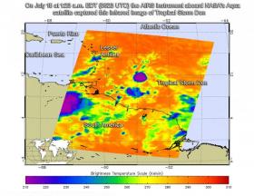
The Atmospheric Infrared Sounder, or AIRS, instrument aboard NASA's Aqua satellite looked at Tropical Storm Don in infrared light. Infrared light provides scientists with temperature data and that's important when trying to understand how strong storms can be. The higher the cloud tops, the colder and the stronger they are. So infrared light as that gathered by the AIRS instrument can identify the strongest storms within a tropical cyclone.
Read more at NASA/Goddard Space Flight Center
Image: On July 18 at 1:23 a.m. EDT (0523 UTC) the AIRS instrument aboard NASA's Aqua satellite captured this infrared image of Tropical Storm Don. The image showed the storm to be compact with a small area of strong thunderstorms (blue) around the center. (Credit: NASA JPL/Ed Olsen)


