Before Hurricane Gert became a post-tropical cyclone, NASA got a look at the rainfall occurring within the storm. After Gert became post-tropical NOAA’s GOES-East satellite captured an image as Gert was merging with another system.
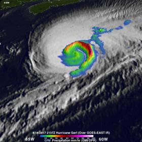
The Global Precipitation Measurement mission or GPM core observatory satellite provided rainfall information on Hurricane Gert on August 16, 2017 at 5:37 p.m. EDT (2137 UTC). At that time, Gert was a strong category two hurricane with maximum sustained winds of about 93.5 mph (85 knots).
Before Hurricane Gert became a post-tropical cyclone, NASA got a look at the rainfall occurring within the storm. After Gert became post-tropical NOAA’s GOES-East satellite captured an image as Gert was merging with another system.
The Global Precipitation Measurement mission or GPM core observatory satellite provided rainfall information on Hurricane Gert on August 16, 2017 at 5:37 p.m. EDT (2137 UTC). At that time, Gert was a strong category two hurricane with maximum sustained winds of about 93.5 mph (85 knots).
Data from GPM's Microwave Imager (GMI) instrument showed that rain was still falling at a rate of more than 2.94 inches (74.7 mm) per hour in a powerful band of storms spiraling around Gert's eastern side. With that pass GPM's Dual-Frequency Precipitation Radar (DPR) had a limited encounter with hurricane Gert. DPR did find that rain in storms on the extreme northeastern edge of the hurricane was falling at a rate of up to 2.8 inches (70.3 mm) per hour. In that area storm tops were found by GPM's radar (DPR Ku band) to reach up to 7.5 miles (12.1 km).
Read more at NASA / Goddard Space Flight Center
Image: On Aug. 16 at 5:37 p.m. EDT the GPM core satellite found rain in storms on Hurricane Gert’s extreme northeastern edge was falling at a rate of up to 2.8 inches (70.3 mm) per hour. In that area storm tops were found by GPM's radar (DPR Ku band) to reach up to 7.5 miles (12.1 km).
Credits: NASA / JAXA, Hal Pierce


