NASA created a dramatic 3-D image of powerful Typhoon Talim using data from the Global Precipitation Measurement mission or GPM core satellite. Talim’s large eye really made the storm stand out as it moved toward landfall.
NASA created a dramatic 3-D image of powerful Typhoon Talim using data from the Global Precipitation Measurement mission or GPM core satellite. Talim’s large eye really made the storm stand out as it moved toward landfall.
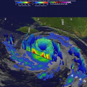
The GPM core observatory had an amazing view of Typhoon Talim in the western Pacific Ocean on September 13, 2017 at 11:37 a.m. EDT (1537 UTC). A large eye was Talim's most distinctive feature. GPM's Microwave Imager (GMI) and Dual-Frequency Precipitation Radar (DPR) showed the location of intense rainfall within Talim's distinct eye wall. DPR revealed that rain was falling at a rate of over 232 mm (9.13 inches) per hour in convective storms in the western side of the typhoon's eye wall. GPM also showed that rainfall was far weaker to the east of Talim's center.
At NASA’s Goddard Space Flight Center in Greenbelt, Maryland, the 3-D view of Talim's eye was produced using data collected by the GPM satellite's radar (DPR Ku Band). Many of the storm tops in the western side of Talim's eye wall were seen extending to heights above 12km (7.4 miles) while they were lower on the eastern side of the typhoon. GPM is a joint mission between NASA and the Japanese space agency JAXA.
Read more at NASA/Goddard Space Flight Center
Image: This a dramatic 3-D view of Talim's eye was taken from the GPM core satellite on Sept. 13, 2017 at 11:37 a.m. EDT Many of the storm tops in the western side of Talim's eyewall are shown extending to heights above 12km (7.4 miles) where rain was falling at a rate of over 232 mm (9.13 inches) per hour. Cloud tops were lower on the eastern side of the typhoon. (Credit: NASA/JAXA, Hal Pierce)


