Infrared imagery provides a look at tropical cyclones at night and NASA-NOAA’s Suomi NPP satellite got a look at Tropical Storm Norma in the Eastern Pacific using infrared light.
Infrared imagery provides a look at tropical cyclones at night and NASA-NOAA’s Suomi NPP satellite got a look at Tropical Storm Norma in the Eastern Pacific using infrared light.
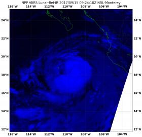
The Visible Infrared Imaging Radiometer Suite (VIIRS) instrument aboard NASA-NOAA’s Suomi NPP satellite captured an infrared light picture Tropical Storm Norma on Sept. 15 at 4:24 a.m. EDT (0924 UTC). The VIIRS image showed Norma’s center just east of Socorro Island.
At 11 a.m. EDT (1500 UTC) on Sept. 15 the center of Tropical Storm Norma was located near 18.7 degrees north latitude and 109.7 degrees west longitude. The VIIRS image showed Norma has an elongated band of thunderstorms that curls about three quarters of the way around the low-level center. Norma’s center was about 85 miles (135 km) east of Socorro Island.
Continue reading at NASA / Goddard Space Flight Center
Image: On Sept. 15 at 4:24 a.m. EDT (0924 UTC) NASA-NOAA’s Suomi NPP satellite captured this infrared image of Tropical Storm Norma near Socorro Island in the Eastern Pacific Ocean, off the coast of western Mexico. Credits: NOAA / NASA / NRL


