NASA and NOAA satellites have provided data on Maria as it strengthened into a major Hurricane headed toward the Leeward Islands. NASA's Aqua satellite provided an infrared look at Maria that showed cooling cloud top temperatures and NOAA's GOES satellite provided an animation of imagery that showed the storm developing and strengthening. The GPM satellite found "Hot" towering clouds that indicated strengthening was occurring before Maria became a major hurricane.
NASA and NOAA satellites have provided data on Maria as it strengthened into a major Hurricane headed toward the Leeward Islands. NASA's Aqua satellite provided an infrared look at Maria that showed cooling cloud top temperatures and NOAA's GOES satellite provided an animation of imagery that showed the storm developing and strengthening. The GPM satellite found "Hot" towering clouds that indicated strengthening was occurring before Maria became a major hurricane.
Warnings and Watches on Sept. 18
The National Hurricane Center (NHC) issued a Hurricane Warning for Guadeloupe, Dominica, St. Kitts, Nevis, and Montserrat, Martinique, St. Lucia, U.S. Virgin Islands and the British Virgin Islands. A Tropical Storm Warning is in effect for Antigua and Barbuda, Saba and St. Eustatius, St. Maarten and Anguilla.
A Hurricane Watch is in effect for Puerto Rico, Vieques, and Culebra, Saba and St. Eustatius, St. Maarten, St. Martin and St. Barthelemy, and Anguilla. A Tropical Storm Watch is in effect for Barbados, St. Vincent and the Grenadines.
Read more at NASA / Goddard Space Flight Center
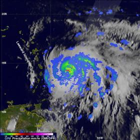
Image: On Sept. 17, 2017 at 1001 p.m. EDT the GPM core satellite showed that Maria found rain falling at a rate of over 6.44 inches (163.7 mm) per hour in powerful storms northeast of Maria's eye. Intense thunderstorms were found towering to above 9.7 miles (15.7 km). Credits: NASA / JAXA, Hal Pierce


