Satellite imagery shows that Jose is a large storm, with a large reach. NASA’s Aqua satellite captured cloud top temperatures of Tropical Storm Jose that revealed the strongest storms were in the northeastern part of the tropical cyclone but the storm is so large that it is causing dangerous ocean conditions from Bermuda to the U.S. East coast.
Satellite imagery shows that Jose is a large storm, with a large reach. NASA’s Aqua satellite captured cloud top temperatures of Tropical Storm Jose that revealed the strongest storms were in the northeastern part of the tropical cyclone but the storm is so large that it is causing dangerous ocean conditions from Bermuda to the U.S. East coast.
Tropical-storm-force winds extend outward up to 205 miles (335 km) from the center. Despite the strongest side facing away from the coast, dangerous surf and rip currents expected to continue for several more days along much of the east coast of the United States.
On Sept. 20, a Tropical Storm Warning is in effect for Woods Hole to Sagamore Beach, including Cape Cod, Massachusetts, Block Island, Martha's Vineyard and Nantucket Island.
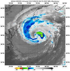
The Moderate Resolution Imaging Spectroradiometer or MODIS instrument that flies aboard NASA's Aqua satellite captured infrared data on Tropical Storm Jose on Sept. 20 at 2:55 a.m. EDT (0655). Infrared data provides temperature information to scientists. Cloud top temperatures are an important factor when it comes to determining the strength of storms. The higher the cloud tops, the colder and the stronger the storms.
Read more at NASA/Goddard Space Flight Center
Image: The MODIS instrument aboard NASA's Aqua satellite captured infrared data on Tropical Storm Jose on Sept. 20 at 2:55 a.m. EDT (0655). Strongest storms appear in yellow, northeast of the center. A band of thunderstorms were over Cape Cod, Mass. and the eastern tip of Long Island, New York. (Credit: NASA/NRL)


