NASA looked into Hurricane Maria and found that powerful convective storms within the hurricane were dropping heavy rainfall. Maria brought that heavy rainfall to Puerto Rico and made landfall on Sept. 20 at 6:15 a.m. EDT.
NASA looked into Hurricane Maria and found that powerful convective storms within the hurricane were dropping heavy rainfall. Maria brought that heavy rainfall to Puerto Rico and made landfall on Sept. 20 at 6:15 a.m. EDT.
The Global Precipitation Measurement mission, or GPM, core observatory satellite collected data on rainfall rates as it passed above Hurricane Maria earlier on Sept. 19 at 9:51 p.m. AST/EDT (Sept. 20 0151 UTC). The rainfall analysis was derived from GPM's Microwave Imager (GMI) and Dual-Frequency Precipitation Radar (DPR) data received by the satellite. GPM's radar (DPR Ku band) found that some extreme storms within the hurricane's feeder bands were dropping rain at a rate of greater than 5.4 inches (137 mm) per hour.
Read more at NASA/Goddard Space Flight Center
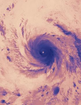
Image: NASA-NOAA’s Suomi NPP satellite VIIRS instrument captured this thermal image on Sept. 20, 2017, at 2:12 a.m. EDT (0612 UTC). At the time, Maria’s eye was just east of the American Virgin Islands, and its northwestern quadrant stretched over Puerto Rico.
Credits: NASA Goddard Rapid Response Team


