Tropical Depression Pilar weakened to a remnant low pressure area as it continued to crawl north along the west coast of Mexico. Satellite data revealed no circulation center.
Tropical Depression Pilar weakened to a remnant low pressure area as it continued to crawl north along the west coast of Mexico. Satellite data revealed no circulation center.
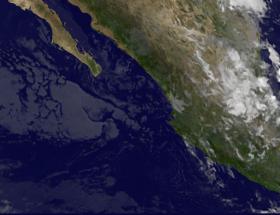
NOAA's GOES West satellite provided an infrared image of Mexico's west coast on Sept. 26 at 7:45 a.m. (1145 UTC). The image showed disorganized clouds south of Baja California. The infrared image makes the clouds appear transparent in the image.
NOAA manages the GOES series of satellites and the NASA/NOAA GOES Project at NASA's Goddard Space Flight Center in Greenbelt Md. uses the data to produce images and animations.
Read more at NASA / Goddard Space Flight Center
Image: NOAA's GOES West satellite provided an infrared image of Mexico's west coast on Sept. 26 at 7:45 a.m. (1145 UTC). The image showed disorganized clouds south of Baja California. The infrared image makes the clouds appear transparent in the image.
Credits: NASA/NOAA GOES Project


