NASA analyzed the rainfall generated by short-lived Tropical Cyclone 04B that formed and faded over a day in the Bay of Bengal.
NASA analyzed the rainfall generated by short-lived Tropical Cyclone 04B that formed and faded over a day in the Bay of Bengal.
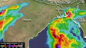
A substantial area of the Northern Indian Ocean was recently covered with cloudiness and rain showers as a large tropical low pressure area moved over the warm waters of the Bay of Bengal. After being closely monitored for over a week, the tropical disturbance intensified briefly to tropical storm force in the northern Bay of Bengal. It was labeled tropical cyclone 04B on December 9, 2017. The weak system produced moderate to heavy rainfall along northeastern India's Bay of Bengal coastline, moved over southern Bangladesh and dissipated over northwestern Burma.
At NASA's Goddard Space Flight Center in Greenbelt, Maryland, a rainfall accumulation analysis was created on 04B. It was derived from NASA's Integrated Multi-satellitE Retrievals data (IMERG).
NASA's GPM or Global Precipitation Measurement mission satellite provides information on precipitation from its orbit in space. GPM is a joint mission between NASA and the Japan Aerospace Exploration Agency or JAXA. GPM also utilizes a constellation of other satellites to provide a global analysis of precipitation that are used in the IMERG calculation.
Read more at NASA/Goddard Space Flight Center
Image: This IMERG rainfall analysis from Dec. 4 to 11 shows the rainfall dropped by former Tropical Cyclone Ockhi in western India, and Tropical Cyclone 04B in eastern India. (Credit: NASA/JAXA, Hal Pierce)


