The first tropical depression of the northwestern Pacific Ocean 2018 tropical cyclone season didn't waste any time forming after the first of the new year. Tropical Depression 1W formed just west of the Philippines in the Sulu Sea as NASA's Terra satellite passed overhead early on Jan. 2, 2018.
The first tropical depression of the northwestern Pacific Ocean 2018 tropical cyclone season didn't waste any time forming after the first of the new year. Tropical Depression 1W formed just west of the Philippines in the Sulu Sea as NASA's Terra satellite passed overhead early on Jan. 2, 2018.
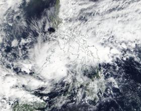
The Moderate Resolution Imaging Spectroradiometer or MODIS instrument that flies aboard Terra provided a visible-light image of the depression on Jan. 2, 2018. The image showed strong thunderstorm development northwest of the center. Animated infrared imagery also showed flaring convection confined to the northwest of the low level circulation center.
At 10 a.m. EST (1500 UTC) on Jan. 2, 2018, Tropical Depression 01w (01W) was located approximately 335 nautical miles south-southwest of Manila, Philippines, near 9.5 degrees north latitude and 118.0 degrees east longitude. 01W was moving to the west at 20.7 mph (18 knots/33.3 kph) and had maximum sustained winds near 34.5 mph (30 knots /55.5 kph).
Read more at NASA/Goddard Space Flight Center
Image: NASA's Terra satellite captured a visible-light image of Tropical Depression 01W on Jan. 2, 2018. The image showed strong thunderstorm development northwest of the center. (Credit: NASA Rapid Response Team)


