NASA-NOAA's Suomi NPP passed over newly formed Tropical Storm Ava and analyzed the storm in infrared light. Ava, the third tropical cyclone of the Southern Indian Ocean season formed off the coast of northeastern Madagascar on Jan. 3.
NASA-NOAA's Suomi NPP passed over newly formed Tropical Storm Ava and analyzed the storm in infrared light. Ava, the third tropical cyclone of the Southern Indian Ocean season formed off the coast of northeastern Madagascar on Jan. 3.
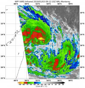
On Jan. 3 at 4:12 a.m. EDT (0912 UTC) the Visible Infrared Imaging Radiometer Suite (VIIRS) instrument aboard NASA-NOAA's Suomi NPP satellite provided gathered infrared data of Ava. The Infrared data provided forecasters with temperatures that indicated where the strongest storms were located within the tropical storm. Coldest clouds tops and strongest storms wrapped around the center of circulation where temperatures were as cold as or colder than minus 80 degrees Fahrenheit (minus 62.2 Celsius). NASA research has shown that storms with cloud top temperatures that cold can produce heavy rainfall.
At 10 a.m. EST (1500 UTC), the center of Ava was located near 6.2 degrees south latitude and 53.0 degrees east longitude. Ava was centered about 298 nautical miles north-northwest of St. Denis. Ava was moving toward the south-southeast near 6 knots (7 mph/11 kph). Maximum sustained winds are near 40 mph (46 mph/74 kph) with higher gusts.
Swells generated by Ava will affect the east coast as the storm moves in a southerly direction.
Read more at NASA/Goddard Space Flight Center
Image: On Jan. 3 at 4:12 a.m. EDT (0912 UTC) the VIIRS instrument aboard NASA-NOAA's Suomi NPP satellite provided this infrared image of Tropical Storm Ava near northeastern Madagascar. Coldest clouds tops and strongest storms appear in red and yellow. (Credit: NOAA/NASA/NRL)


