Heavy rain surrounded Tropical Cyclone Berguitta as it continued to move toward the island of Mauritius in the Southern Indian Ocean. NASA calculated the rate in which rain was falling within the hurricane-strength storm in the Southern Indian Ocean.
Heavy rain surrounded Tropical Cyclone Berguitta as it continued to move toward the island of Mauritius in the Southern Indian Ocean. NASA calculated the rate in which rain was falling within the hurricane-strength storm in the Southern Indian Ocean.
Tropical Cyclone Berguitta formed in the southwestern Indian Ocean northeast of the islands of La Reunion and Mauritius on January 12, 2018. Berguitta is now moving toward the southwest and threatening the islands.
Early on January 16, 2018 Berguitta had maximum sustained winds estimated at 100 knots (115 mph). This means that Berguitta was the equivalent of a category three hurricane on the Saffir-Simpson hurricane wind scale. Later in the day Berguitta's maximum sustained wind speeds were estimated at 85 knots (98 mph) with gust to 105 knots (121 mph). On January 16, 2018 at 7 a.m. EST (1200 UTC) Tropical Cyclone Berguitta was 244 nautical miles east-northeast of Port Louis, Mauritius.
The Global Precipitation Measurement mission or GPM core satellite provides a look at the rate in which precipitation falls within storms. GPM is a joint mission between NASA and the Japan Aerospace Exploration Agency, JAXA.
Read more at NASA/Goddard Space Flight Center
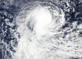
Image: NASA's Aqua satellite captured this visible-light image of Tropical Cyclone Berguitta on Jan. 17 when it was located northeast of Mauritius. (Credit: NASA Goddard Rapid Response Team)


