
NOAA image of Richard W. Spinrad (right), director of NOAA's Office of Oceanic and Atmospheric Research, standing beside the tsunami buoy that will be deployed in the Indian Ocean. September 19, 2007 — Representatives of the governments and scientific communities of the United States and Indonesia marked a historic moment today in Jakarta, Indonesia, as the two countries jointly launched tsunami and climate-monitoring ocean buoys in the region. The ship embarked from Jakarta today to launch the second buoy to warn of approaching tsunamis and four buoys to monitor climate.
September 19, 2007 — Representatives of the governments and scientific communities of the United States and Indonesia marked a historic moment today in Jakarta, Indonesia, as the two countries jointly launched tsunami and climate-monitoring ocean buoys in the region. The ship embarked from Jakarta today to launch the second buoy to warn of approaching tsunamis and four buoys to monitor climate.
The buoys are the latest additions to the expanding Global Earth Observation System of Systems, an international effort to monitor and predict changes in the Earth to benefit the environment, human health and the economy.
“The recent strong earthquakes in Indonesia highlight the importance of effective tsunami warning and mitigation systems. We have been working in partnership with Indonesia to provide research, development and operational capacity through technical exchange in one of the most tsunami-prone countries in the world,” said Richard W. Spinrad, NOAA director of ocean and atmospheric research. “Today, we were all gratified to see the efforts of that collaboration as the Indonesian Research Vessel Baruna Jaya III headed out to sea with U.S. technology aboard.”
Spinrad noted that the deployment of the buoys, expected to be completed by the first week in October, represents a joint U.S.-Indonesia contribution to the Indian Ocean region.
DART buoy deployments as of March 2007. Please credit “NOAA.”NOAA deployed the first operational tsunami detection system in the Indian Ocean in 2006. The two Deep-ocean Assessment and Reporting of Tsunami (DART™) II will be the only operational tsunami-detecting devices in the Indian Ocean. (Click NOAA image for larger view of DART buoy deployments as of March 2007. Click here for high resolution version. Please credit “NOAA.”)
The deployment is funded under a US Agency for International Development program (USAID) to make strategic investments in support of the Indian Ocean Tsunami Warning System (IOTWS). NOAA provided the key technical expertise behind the Indian Ocean Tsunami Warning System and has engaged in a $4.5 million effort, and is contributing technology and training to help the region create round-the-clock coverage for the region, which was devastated by the Dec. 26, 2004, Indian Ocean tsunami.
Since the 2004 tsunami, the United States and NOAA have worked with USAID, Indonesia and other partners to build an end-to-end tsunami warning system in the region with the member states of the Intergovernmental Oceanographic Commission of UNESCO, the United Nations Environment, Science, and Cultural Organization.
“Not only will this warning system benefit Indian Ocean communities, it is a prime example of NOAA’s scientific research creating value for society,” said Spinrad, who also serves as the U.S. permanent representative to the Intergovernmental Oceanographic Commission. The IOC is facilitating the IOTWS.
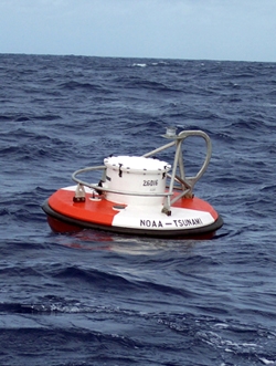
The new DART II buoy will augment another DART II deployed in the Indian Ocean by the U.S. and Thailand in December 2006.
The DART system was developed by NOAA’s Pacific Marine Environmental Laboratory in Seattle, Wash., and is more generically called a tsunameter — a sophisticated pressure gauge set on the ocean floor monitoring sea-level changes and supporting two-way communication via surface buoy and satellite to monitoring centers on shore.
The ATLAS climate moorings are the backbone of the TAO/TRITON array, which consists of approximately 70 moorings in the Tropical Pacific Ocean, gathering information about the ocean and atmosphere, then sending that data to shore in real-time by the Argos satellite system. NOAA extended this array into the Indian Ocean in October 2004.
The array is a major component of the El Niño/Southern Oscillation Observing System, the Global Climate Observing System and the Global Ocean Observing System.
NOAA, an agency of the U.S. Commerce Department, is celebrating 200 years of science and service to the nation. From the establishment of the Survey of the Coast in 1807 by Thomas Jefferson to the formation of the Weather Bureau and the Commission of Fish and Fisheries in the 1870s, much of America's scientific heritage is rooted in NOAA.
!ADVERTISEMENT!
NOAA is dedicated to enhancing economic security and national safety through the prediction and research of weather and climate-related events and information service delivery for transportation, and by providing environmental stewardship of our nation's coastal and marine resources. Through the emerging Global Earth Observation System of Systems (GEOSS), NOAA is working with its federal partners, more than 70 countries and the European Commission to develop a global monitoring network that is as integrated as the planet it observes, predicts and protects.
Relevant Web Sites
NOAA
NOAA Real-time DART Buoy Data
Deep-ocean Assessment and Reporting of Tsunamis (DART™)
NOAA Tsunami Portal


