
Looking down upon the Earth gives one the big picture. Up high in the sky are many man made satellites that are designed to look down and send information to various places. NASA is currently designing a pair of robotic probes to keep tabs on how the planet is changing and to help forecasters predict natural disasters, such as volcanic eruptions, earthquakes and landslides.
Looking down upon the Earth gives one the big picture. Up high in the sky are many man made satellites that are designed to look down and send information to various places. NASA is currently designing a pair of robotic probes to keep tabs on how the planet is changing and to help forecasters predict natural disasters, such as volcanic eruptions, earthquakes and landslides.
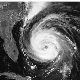
!ADVERTISEMENT!Hurricaines or cyclones are one of the more visual phenomena of satellite monitoring i ntracking the progress of these storms. Satelliteds have been used for decades to help predict and monitor such potential natural disasters.
China launched two satellites in September 2008 to monitor the environment and natural disasters.
The two Chinese satellites were launched from the Taiyuan Satellite Launch Center, and were expected to enhance the country's capacity to forecast natural disasters.
One of the new NASA spacecraft will use radar to look for telltale signs of imminent disaster as it precisely measures small deformations in Earth's surface over time. Scientists hope to be able to zero in on regions that may be in danger so residents can prepare. Volcanoes, for example, will expand when their internal pressure increases. This change could be useful in predicting an eruption. Such land deformations would also be useful in predicting potential quake zones and landslides.
Satellites can transmit information during or before natural disasters using their on-board communication equipment. A satellite can take pictures of locations human beings cannot reach during a disaster. Satellites can gather images using their on-board cameras and downlink the information to the local disaster command center. As satellites are much higher than aircraft, their function is not inhibited by poor flying weather conditions.
The second new NASA satellite will be equipped with an optical remote sensing tool called LIDAR -- Light Detection And Ranging -- that will pulse laser light on Earth and measure the time it takes for the reflected signals to return. The technique is good for measuring the density of a forest, for example, as the light bouncing off the tops of trees will have a different return signal than light reflecting off bare ground.
Scientists hope to use the information to figure out how carbon is cycling through the planet's ecosystem -- information that is important for understanding global climate change.
LIDAR has been already been used successfully in many fields of application such geology, meteorology, and archaeology.
For further information: http://news.discovery.com/space/satellites-prediction-natural-disasters.html#mkcpgn=rssnws1


