
A NASA analysis of satellite data has quantified, for the first time, the amount of older and thicker multi-year sea ice lost from the Arctic Ocean due to melting. Since the start of the satellite record in 1979, scientists have observed the continued disappearance of older multi-year sea ice that survives more than one summer melt season. Some scientists suspected that this loss was due entirely to wind pushing the ice out of the Arctic Basin -- a process that scientists refer to as export. Kwok and Cunningham, in their study, show that between 1993 and 2009, a significant amount of multi-year ice - 336 cubic miles) - was lost due to melt, not export.
A NASA analysis of satellite data has quantified, for the first time, the amount of older and thicker multi-year sea ice lost from the Arctic Ocean due to melting. Since the start of the satellite record in 1979, scientists have observed the continued disappearance of older multi-year sea ice that survives more than one summer melt season. Some scientists suspected that this loss was due entirely to wind pushing the ice out of the Arctic Basin - a process that scientists refer to as export. Kwok and Cunningham, in their study, show that between 1993 and 2009, a significant amount of multi-year ice - 336 cubic miles) - was lost due to melt, not export.
!ADVERTISEMENT!
Arctic shrinkage is the decrease in size of the Arctic region (In simpler terms this is the ice at the north pole.) This is a change in the regional climate that may be the result of global warming. Projections of the current sea ice loss suggest that the Arctic ocean will likely be free of summer sea ice sometime between 2060 and 2080 while another estimate puts this date at 2030. Recognize that these are projections that may not occur.
Reliable measurement of sea ice edge begin within the satellite era in the late 1970s. Before this time the region was less well monitored by a combination of ships, buoys and aircraft. On top of the long-term negative trend in recent years there is considerable interannual variation. Some of this variation may be related to effects such as the arctic oscillation which is the variability of weather over the years.
"The {new} paper shows that there is indeed melt of old ice within the Arctic basin and the melt area has been increasing over the past several years," Kwok said. "The story is always more complicated - there is melt as well as export - but this is another step in calculating the mass and area balance of the Arctic ice cover."
The study was published in October 2010 in Geophysical Research Letters.
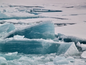
Scientists track the annual cycle of Arctic sea ice coverage as it melts through the summer to reach a minimum extent each September, before refreezing through fall and winter. Much of that ice is seasonal, meaning that it forms and melts within the year.
But multi-year ice that survives more than one season has also been declining, as noted in previous work by Joey Comiso of NASA's Goddard Space Flight Center in Greenbelt, Md., who shows a loss of about 10 percent per decade since the beginning of the satellite record in 1979.
"The decline of the multi-year ice cover of the last several decades has not been quantitatively explained," Kwok said.To investigate the loss of multi-year ice, Kwok and Cunningham looked at a 17 year span of data from 1993 to 2009 from a range of polar-observing satellites and instruments, including NASA's Quick Scatterometer (QuikScat); the Ice, Cloud and land Elevation Satellite (ICESat); the Advanced Microwave Scanning Radiometer (AMSR); and the European Space Agency's European Remote Sensing (ERS)-1 and -2 satellites. Some of these instruments track ice coverage, while others track motion and concentration.
The team collected satellite images and tracked pixels of multi-year ice from April 1, prior to the onset of seasonal melt, and into the summer. Pixels that deviated away from images of the ice edge were considered lost to melt.The team compared summertime melt of multi-year ice in the Beaufort Sea with estimates of ice lost from the Arctic basin through the Fram Strait. The comparison revealed how much multi-year ice was lost to export and how much was lost to melt.
The Fram Strait is a passage from the Arctic Ocean to the Greenland Sea and Norwegian Sea, between Greenland and Spitsbergen. The Fram strait plays a key role in whether the north ice cap will survive future summers. Approximately 90% of sea ice exported from the Arctic is transported by the Eastern Greenland Current, joining the current as it passes through the Fram Strait.
The new study found that over the 17 year period, an area of 365,639 square miles, or about 32 percent of the decline in multi-year sea ice area, was lost in the Beaufort Sea due to melt.
A similar calculation using thickness estimates from NASA's ICESat from 2004 to 2009 show a volume loss of 336 cubic miles, or about 20 percent of the total loss by volume. How and where multi-year ice is lost has impacts on the Arctic system. For example, more loss by melt means more freshwater remains in local Arctic waters rather than being transported southward.
Not all of the multi-year ice loss is accounted for, however. Ice loss through Fram Strait and from melt from 2005 to 2008 accounts for just 52 percent of total ice loss. The team suggests that melt in other Arctic regions and outflow through other passages besides Fram Strait could account for the difference.
For further information: http://www.jpl.nasa.gov/news/news.cfm?release=2010-379&rn=news.xml&rst=2811


