
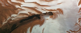
A newly released image from ESA’s Mars Express shows the north pole of Mars during the red planet’s summer solstice. All the carbon dioxide ice has gone, leaving just a bright cap of water ice. This image was captured by the orbiter’s High-Resolution Stereo Camera on May 17, 2010 and shows part of the northern polar region of Mars during the summer solstice. The solstice is the longest day and the beginning of the summer for the planet’s northern hemisphere. The ice shield is covered by frozen water and carbon dioxide ice in winter and spring but by this point in the martian year all of the carbon dioxide ice has warmed and evaporated into the planet’s atmosphere.
A newly released image from ESA’s Mars Express shows the north pole of Mars during the red planet’s summer solstice. All the carbon dioxide ice has gone, leaving just a bright cap of water ice. This image was captured by the orbiter’s High-Resolution Stereo Camera on May 17, 2010 and shows part of the northern polar region of Mars during the summer solstice. The solstice is the longest day and the beginning of the summer for the planet’s northern hemisphere. The ice shield is covered by frozen water and carbon dioxide ice in winter and spring but by this point in the martian year all of the carbon dioxide ice has warmed and evaporated into the planet’s atmosphere.
!ADVERTISEMENT!
Mars is called a terrestrial planet, because it is composed of rocky material, like Mercury, Venus, and Earth. Mars has some of the same geological features as Earth, including volcanoes, valleys, ridges, plains, and canyons.
Planum Boreum is the northern polar plain on Mars. It extends northward from roughly 80°N and is centered at 88.0°N 15.0°E. Surrounding the high polar plain is a flat and featureless lowland plain called Vastitas Borealis which extends for approximately 1500 kilometers southwards, dominating the northern hemisphere. In 1999, the Hubble Space Telescope captured a cyclonic storm in the region. The diameter of the storm was approximately 1750 km and featured an eye 320 kilometers in diameter.
The polar ice follows the seasons. In winter, part of the atmosphere recondenses as frost and snow on the northern cap. These seasonal deposits can extend as far south as 45°N latitude and be up to a meter thick.Another phenomenon occurs on the curved scarps of the northern polar cap, such as the Rupes Tenuis slope (on the left of this image). During spring, the seasonal carbon dioxide layer is covered by water frost.
At certain times, winds remove the the millimeter-thick top layer of frozen water, revealing the carbon dioxide ice below.These processes bear witness to a dynamic water cycle on Mars and may lead to the varying accumulation of water ice over the polar cap.
Other noticeable features in this image include the Chasma Boreale canyon, colored deposits and a large dune field.Chasma Boreale is about 2 km deep, 580 km long and about 100 km wide. Its walls allow a perfect view into the strata within the deposits.
There are impact craters on the canyon floor, some heavily covered by sand and some partly exhumed.Dark and light-toned deposits can be seen as a fine and regular covering. The darker sediments have been dropped by the winds during spring dust storms. The patterns are created when the deposits change in quantity according to the seasons. The polar cap is surrounded by a large dune field, parts of which extend 600 km to the south.
For further information: http://www.esa.int/esaCP/SEMA4VITPQG_index_0.html


