
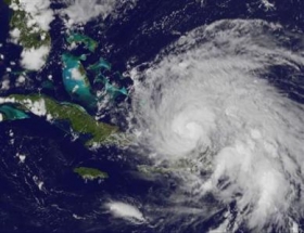
Hurricane Irene looked set to become a major storm on Wednesday as it roared up from the Caribbean on a path that prompted residents along the U.S. east coast to prepare for a possible hit over the weekend. Irene is a Category 2 storm on the five-step Saffir Simpson scale, with top winds of 110 miles per hour (175 km per hour), the U.S. National Hurricane Center said. "Strengthening is forecast and Irene will likely become a major hurricane later today," the center said. It will become a Category 3 storm when winds rise above 111 mph. Even as the first hurricane of the 2011 Atlantic season pounded the Turks and Caicos Islands and the southeast Bahamas with winds, rain and high tides, people in the Carolinas on the southeastern U.S. coast were getting ready for its approach.
Hurricane Irene looked set to become a major storm on Wednesday as it roared up from the Caribbean on a path that prompted residents along the U.S. east coast to prepare for a possible hit over the weekend.
!ADVERTISEMENT!
Irene is a Category 2 storm on the five-step Saffir Simpson scale, with top winds of 110 miles per hour (175 km per hour), the U.S. National Hurricane Center said.
"Strengthening is forecast and Irene will likely become a major hurricane later today," the center said.
It will become a Category 3 storm when winds rise above 111 mph.
Even as the first hurricane of the 2011 Atlantic season pounded the Turks and Caicos Islands and the southeast Bahamas with winds, rain and high tides, people in the Carolinas on the southeastern U.S. coast were getting ready for its approach.
At 5 a.m. EDT, Irene was about 370 miles southeast of Nassau and about 955 miles south of Cape Hatteras in North Carolina.
Irene, the ninth named storm of the June-through-November season, looks set to be the first hurricane to hit the United States since Ike pounded the Texas coast in 2008. But forecasts showed it posing no threat to U.S. oil and gas installations in the Gulf of Mexico.
The hurricane center warned of "an extremely dangerous storm surge" that will raise water levels by as much as 11 feet above normal tides in the central and northwestern Bahamas and by as much as 8 feet in the southeastern Bahamas and the Turks and Caicos.
The storm is forecast to approach the coast of the Carolinas on Saturday morning. After that, the saturated New England region could be at risk from torrential rains, high winds and flooding from Irene, Federal Emergency Management Agency Administrator Craig Fugate said on Tuesday.
Major eastern cities like Washington and New York could feel some impact, the forecasts showed.
Photo credit: NASA
Article continues: http://www.reuters.com/article/2011/08/24/us-storm-irene-idUSTRE77K01820110824


