
Dead zones are hypoxic (low-oxygen) areas in the world's oceans, the observed incidences of which have been increasing since oceanographers began noting them in the 1970s. These occur near inhabited coastlines, where aquatic life is most concentrated A team of NOAA-supported scientists is predicting that this year's Gulf of Mexico hypoxic zone could range from a low of approximately 1,197 square miles to as much as 6,213 square miles. The wide range is the result of using two different forecast models. The forecast is based on Mississippi River nutrient inputs compiled annually by the U.S. Geological Survey (USGS). The Gulf of Mexico dead zone is typically about 8,000 square miles and is located where the Mississippi River dumps high-nutrient runoff from its vast drainage basin, which includes the heart of U.S. agribusiness, the Midwest. This is equivalent to a dead zone the size of New Jersey.
0ead zones are hypoxic (low-oxygen) areas in the world's oceans, the observed incidences of which have been increasing since oceanographers began noting them in the 1970s. These occur near inhabited coastlines, where aquatic life is most concentrated A team of NOAA-supported scientists is predicting that this year's Gulf of Mexico hypoxic zone could range from a low of approximately 1,197 square miles to as much as 6,213 square miles. The wide range is the result of using two different forecast models. The forecast is based on Mississippi River nutrient inputs compiled annually by the U.S. Geological Survey (USGS). The Gulf of Mexico dead zone is typically about 8,000 square miles and is located where the Mississippi River dumps high-nutrient runoff from its vast drainage basin, which includes the heart of U.S. agribusiness, the Midwest. This is equivalent to a dead zone the size of New Jersey.
!ADVERTISEMENT!
The smaller dead zone forecast, covering an area slightly larger than the state of Rhode Island, comes from researchers from the University of Michigan. Their predicted size is based solely on the current year's spring nutrient inputs from the Mississippi River which are significantly lower than average due to drought conditions throughout much of the river watershed.
The larger dead zone forecast, the equivalent of an area the size of the state of Connecticut, is from Louisiana Universities Marine Consortium and Louisiana State University scientists. The Louisiana forecast model includes prior year's nutrient inputs which can remain in bottom sediments and be recycled the following year. Last year's flood, followed by this year's low flows, increased the influence of this "carryover effect" on the second model's prediction.
Hypoxia is caused by excessive nutrient pollution from human activities coupled with other factors that deplete the oxygen required to support most marine life in bottom and near-bottom water.
During May 2012 stream-flow rates in the Mississippi and Atchafalaya Rivers were nearly half that of normal conditions. This resulted in a decrease in the amount of nitrogen transported by the rivers into the Gulf. According to USGS estimates, 58,100 metric tons of nitrogen (in the form of nitrite plus nitrate) were transported in May 2012 by the Mississippi and Atchafalaya Rivers to the northern Gulf. The amount of nitrogen transported to the Gulf in May 2012 was 56 percent lower than average May nitrogen loads estimated in the last 33 years.
The two smallest recorded dead zones to date are in 2000 when it measured 1,696 square miles and a 15 square miles dead zone in 1988. Last year's dead zone measured 6,765 square miles. The largest hypoxic zone measured to date occurred in 2002 encompassing more than 8,400 square miles.
The actual size of the 2012 hypoxic zone will be released following a NOAA-supported monitoring survey led by the Louisiana Universities Marine Consortium between July 27 and August 3. Collecting these data is an annual requirement of the Mississippi River/Gulf of Mexico Watershed Nutrient Task Force Action Plan. Additional NOAA-supported surveys led by the National Marine Fisheries Service and Texas A&M University will also provide an indication of the progression of the dead zone during the year.
The average of impacted waters over the past five years is approximately 6,000 square miles, much larger than the 1,900 square miles which is the target goal set by the Gulf of Mexico/Mississippi River Watershed Nutrient Task Force.
The hypoxic zone, that form each spring and summer off the coast of Louisiana and Texas, threaten valuable commercial and recreational Gulf fisheries. In 2009, the dockside value of commercial fisheries in the Gulf was $629 million. Nearly three million recreational fishers further contributed about $10 billion to the Gulf economy, taking 22 million fishing trips.
Other known notable dead zones in the United States include the northern Gulf of Mexico region, surrounding the outfall of the Mississippi River, and the coastal regions of the Pacific Northwest, and the Elizabeth River in Virginia Beach, all of which have been shown to be recurring events over the last several years.
For further information see NOAA.
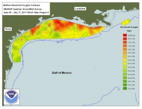
Dead Zone image via Wikipedia/NOAA.


