
Today scientists unveiled new night-time satellite images of planet Earth. Using a NASA and National Oceanic and Atmospheric Administration (NOAA) satellite, the new photographs reveal more detail of our planet and man-made lights from outer space. With a new sensor aboard the NASA-NOAA Suomi National Polar-orbiting Partnership (NPP) satellite, which was launched last year, scientists can better observe the Earth's atmosphere and surface during night-time hours.
Today scientists unveiled new night-time satellite images of planet Earth. Using a NASA and National Oceanic and Atmospheric Administration (NOAA) satellite, the new photographs reveal more detail of our planet and man-made lights from outer space.
!ADVERTISEMENT!
With a new sensor aboard the NASA-NOAA Suomi National Polar-orbiting Partnership (NPP) satellite, which was launched last year, scientists can better observe the Earth's atmosphere and surface during night-time hours.
The new sensor, the day-night band of the Visible Infrared Imaging Radiometer Suite (VIIRS), can detect not only major city lights, but also individual sea ships or even the glow of the Earth's atmosphere.
This and other VIIRS day-night band images are providing researchers with valuable information that can be used to see and predict natural events that happen overnight.
"For all the reasons that we need to see Earth during the day, we also need to see Earth at night," said Steve Miller, a researcher at NOAA's Colorado State University Cooperative Institute for Research in the Atmosphere. "Unlike humans, the Earth never sleeps."
For example the day-night band observed Hurricane Sandy, over New Jersey on the evening of Oct. 29. Night images showed the widespread power outages in addition to moonlit hurricane clouds. With its night view, VIIRS is able to detect a more complete view of storms and other weather conditions, such as fog, that are difficult to discern with infrared, or thermal, sensors. Night is also when many types of clouds begin to form.
"NOAA's National Weather Service is continuing to explore the use of the day-night band," said Mitch Goldberg, program scientist for NOAA's Joint Polar Satellite System. "The very high resolution from VIIRS data will take forecasting weather events at night to a much higher level."
Unlike a camera that captures a picture in one exposure, the day-night band produces an image by repeatedly scanning a scene and resolving it as millions of individual pixels. Then, the day-night band reviews the amount of light in each pixel. If it is very bright, a low-gain mode prevents the pixel from oversaturating. If the pixel is very dark, the signal is amplified. "It's like having three simultaneous low-light cameras operating at once and we pick the best of various cameras, depending on where we're looking in the scene," Miller said. The instrument can capture images on nights with or without moonlight, producing crisp views of Earth's atmosphere, land and ocean surfaces.
Read more and check out the high-resolution images at NASA.gov.
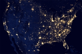
United States Night-time image by Robert Simmon courtesy of Chris Elvidge via NASA Earth Observatory.


