Hurricane Georgette is a major hurricane in the Eastern Pacific Ocean. NASA-NOAA's Suomi NPP satellite provided a visible image of the powerful storm that showed a clear eye.
On July 24, at 21:20 UTC (5:20 p.m. EDT) the Visible Infrared Imaging Radiometer Suite (VIIRS) instrument aboard NASA-NOAA's Suomi NPP satellite captured an image of Hurricane Georgette in the eastern Pacific Ocean that showed an open eye with strong bands of thunderstorms circling the center.
Shortly after Suomi NPP captured the visible image, Georgette's maximum sustained winds had increased to near 130 mph (215 kph) and Georgette became a category 4 hurricane on the Saffir-Simpson Hurricane Wind Scale.
Just 12 hours later, Georgette's eye became cloud-filled as the storm started to weaken. The National Hurricane Center (NHC) noted on July 24 at 11 a.m. EDT (1500 UTC) that "Georgette's small eye has become filled in infrared imagery and the coverage and symmetry of cold tops in the central dense overcast have decreased."
At that time the center of Hurricane Georgette was located near 17.5 north latitude and 127.3 west latitude. That's about 1,185 miles (1,910 km) west-southwest of the southern tip of Baja California, Mexico.
Continue reading at EurekAlert!
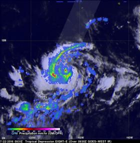
Image: NASA/JAXA's GPM found extremely heavy rain (red) falling at a rate of over 224 mm (8.8 inches) per hour and cloud top heights over 14 km (8.7 miles) high in storms south of Georgette's center.
Credits: NASA/JAXA/SSAI, Hal Pierce


