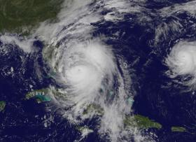
A visible image showing powerful Hurricane Matthew and Nicole on Oct. 6 at 1 p.m. EDT was captured by NOAA's GOES-East satellite. The image shows large Hurricane Matthew's clouds stretching from eastern Cuba and Hispaniola, over the Bahamas and extending to Florida. Matthew is west of the much smaller Tropical Storm Nicole. The image was created at the NASA/NOAA GOES Project at NASA's Goddard Space Flight Center in Greenbelt, Maryland.
A visible image showing powerful Hurricane Matthew and Nicole on Oct. 6 at 1 p.m. EDT was captured by NOAA's GOES-East satellite. The image shows large Hurricane Matthew's clouds stretching from eastern Cuba and Hispaniola, over the Bahamas and extending to Florida. Matthew is west of the much smaller Tropical Storm Nicole. The image was created at the NASA/NOAA GOES Project at NASA's Goddard Space Flight Center in Greenbelt, Maryland.
At 11 a.m. EDT (1500 UTC), the eye of Hurricane Matthew was located near 25.1 degrees north latitude and 77.8 degrees west longitude. That's about 25 miles (40 km) west-northwest of Nassau, Bahamas and 180 miles (290 km) southeast of West Palm Beach, Florida.
NOAA's National Hurricane Center (NHC) said the "eye is moving toward the northwest near 14 mph (22 kph) between Andros Island and Nassau in the Bahamas. This general motion is expected to continue today with a turn toward the north-northwest tonight or early Friday. On the forecast track, Matthew should cross the northwestern Bahamas later today and move close to or over the east coast of the Florida peninsula through Friday night.
Continue reading at NASA
Image Credits: NASA


