NASA-NOAA's Suomi NPP satellite captured a night-time image of Tropical Cyclone Carlos using infrared light that showed the storm was being stretched out. Carlos is being adversely affected by the Westerlies.
NASA-NOAA's Suomi NPP satellite captured a night-time image of Tropical Cyclone Carlos using infrared light that showed the storm was being stretched out. Carlos is being adversely affected by the Westerlies.
The Westerlies are a semi-permanent belt of prevailing westerly winds in the mid-latitudes that are found in both the temperate zones of the northern and southern hemispheres.
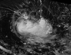
On February 9 the Visible Infrared Imaging Radiometer Suite (VIIRS) instrument aboard the NASA-NOAA Suomi NPP satellite captured an infrared image of Tropical Cyclone Carlos in the Southern Indian Ocean. Infrared imagery detects heat. The VIIRS image showed the thunderstorms around the center of circulation has become more elongated from east to west. Carlos has now moved further into the Westerlies, which have caused the elongation. The winds affecting Carlos are battering the tropical cyclone at a speed between 34.5 mph (30 knots /55.5 kph) and 46 mph (40 knots/74 kph).
Read more at NASA/Goddard Space Flight Center
Photo credit: NOAA/NASA Goddard MODIS Rapid Response Team


