An almost continuous onshore flow is expected to bring storms to California and portions of the Pacific Northwest in a very active, wet pattern over the next couple of days, according to the National Weather Service.
An almost continuous onshore flow is expected to bring storms to California and portions of the Pacific Northwest in a very active, wet pattern over the next couple of days, according to the National Weather Service.
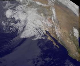
NOAA's GOES-West satellite keeps a constant eye on the western U.S. and the Eastern Pacific Ocean. NOAA manages the Geostationary Operational Environmental Satellite or GOES series of satellites, while NASA/NOAA's GOES Project at NASA's Goddard Space Flight Center in Greenbelt, Maryland uses that data to create images and animations. On Feb. 17 at 1300 UTC (8 a.m. EST) an infrared image showed the large storm system that is expected to bring heavy rain to southern California. Infrared imagery measures temperature and is used to detect clouds at night.
NASA/NOAA's GOES Project also provided a wider view from GOES-West that showed the Eastern and Central Pacific Ocean and two systems. Behind the system currently impacting southern California is another low pressure system to the west, in the Central Pacific Ocean. That system is also headed toward the Pacific coast.
Read more at NASA
Image Credits: NASA/NOAA GOES Project


