The Global Precipitation Measurement mission or GPM constellation of satellites provide data on precipitation rates and totals. Recently the GPM core observatory measured the heavy rainfall that caused extensive flooding and loss of life in Peru.
Extreme flooding and frequent landslides that occurred in March have forced many from their homes. An El Niño-like condition with warm ocean waters developed near Peru's coast. This extremely warm water off Peru's western coast has been blamed for promoting the development of these storms. Equatorial sea surface temperatures (SSTs) are about average elsewhere in the central and east central Pacific.
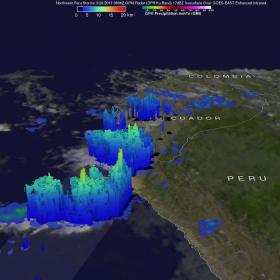
When the GPM core observatory satellite flew above Peru on March 20, 2017 at 0826 UTC (4:26 a.m. EST) GPM identified locations of storms that were dropping heavy rainfall over northwestern Peru. Data collected by GPM's Microwave Imager (GMI) and Dual-Frequency Precipitation Radar (DPR) instruments during this pass revealed that very heavy precipitation was falling in that area. GPM's radar (DPR Ku Band) data indicated that some storms were dropping rain at the extreme rate of greater than 137 mm (5.4 inches) per hour. These extreme rainfall rates were found in the line of storms extending southwestward from Peru's coast.
Read more at NASA / Goddard Space Flight Center
Image: When the GPM core observatory satellite flew above Peru on March 20, 2017 at 0826 UTC (4:26 a.m. EST) GPM identified locations of storms that were dropping heavy rainfall over northwestern Peru.
Image Credits: NASA / JAXA, Hal Pierce


