NASA's Terra satellite captured an infrared image of Tropical Cyclone Donna as it was being sheared apart by winds southeast of New Caledonia.
An infrared image taken May 10 at 11:55 UTC (7:55 a.m. EDT), from the MODIS instrument aboard NASA's Terra satellite showed cloud top temperatures of the dying storm. Strongest thunderstorms with cloud tops so high in the troposphere they were as cold as minus 70 degrees Fahrenheit (minus 56.6 degrees Celsius) were pushed to the southeast of the center from northwesterly wind shear.
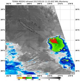
Read more at NASA / Goddard Space Flight Center
Photo: On May 10 at 11:55 UTC (7:55 a.m. EDT), NASA's Terra satellite captured an infrared image of Tropical Cyclone Donna as it was being sheared apart by winds southeast of New Caledonia. (Credits: NASA / NRL)


