NASA’s Aqua satellite captured an image of Tropical Storm Cindy after it formed and was already affecting the U.S. Gulf Coast states. Cindy continues to crawl toward land and Tropical Storm warnings are in effect for June 21.
On June 21 at 11 a.m. EDT, a Tropical Storm Warning is in effect for San Luis Pass, Texas to the mouth of the Mississippi River.
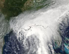
When NASA’s Aqua satellite passed over the Gulf of Mexico on June 20 at 19:15 UTC (3:15 p.m. EDT), Tropical Depression 3 was already upgraded to Tropical Storm status and named Cindy. The storm was classified as a tropical storm at 2 p.m. EDT. The Moderate Resolution Imaging Spectroradiometer or MODIS instrument aboard Aqua showed Cindy’s center of circulation in the central Gulf of Mexico with a large area of thunderstorms sweeping from northwest to southeast of the center, stretching from eastern Texas to Florida.
NASA’s Aqua satellite captured an image of Tropical Storm Cindy after it formed and was already affecting the U.S. Gulf Coast states. Cindy continues to crawl toward land and Tropical Storm warnings are in effect for June 21.
On June 21 at 11 a.m. EDT, a Tropical Storm Warning is in effect for San Luis Pass, Texas to the mouth of the Mississippi River.
When NASA’s Aqua satellite passed over the Gulf of Mexico on June 20 at 19:15 UTC (3:15 p.m. EDT), Tropical Depression 3 was already upgraded to Tropical Storm status and named Cindy. The storm was classified as a tropical storm at 2 p.m. EDT. The Moderate Resolution Imaging Spectroradiometer or MODIS instrument aboard Aqua showed Cindy’s center of circulation in the central Gulf of Mexico with a large area of thunderstorms sweeping from northwest to southeast of the center, stretching from eastern Texas to Florida.
The National Hurricane Center or NHC noted on June 21 that “Heavy rainfall could produce life-threatening flash flooding across portions of the northern Gulf coast.”
An enhanced image from NOAA’s GOES-East satellite was created by the University of Wisconsin-Madison Cooperative Institute for Meteorological Satellite Studies or CIMSS. The image showed cloud top temperatures in bands of thunderstorms north and east of Tropical Storm Cindy’s center on June 21 at 14:45 UTC (10:45 a.m. EDT). Some of those temperatures were as cold as minus 70 degrees Fahrenheit. Those are strong storms that were located over the Gulf of Mexico just south of Galveston, over the Florida panhandle, and over the central Gulf of Mexico. Storms with cloud top temperatures that cold have been found to generate heavy rainfall.
Read more at NASA's Goddard Space Flight Center
Image: This enhanced image from NOAA’s GOES-East satellite shows cloud top temperatures in bands of thunderstorms north and east of Tropical Storm Cindy’s center on June 21 at 14:45 UTC (10:45 a.m. EDT). Credits: NOAA / UWM-CIMSS


