Former Hurricane Eugene has now weakened to a remnant low pressure area. Infrared imagery from NASA's Aqua satellite revealed that only a small area of convection remains.
Former Hurricane Eugene has now weakened to a remnant low pressure area. Infrared imagery from NASA's Aqua satellite revealed that only a small area of convection remains.
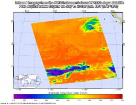
On July 12 at 5:47 p.m. EDT (2147 UTC) the Atmospheric Infrared Sounder, or AIRS, instrument aboard NASA's Aqua satellite captured infrared temperature data of post-tropical cyclone Eugene that showed the convection, rising air that forms clouds and thunderstorms that make up a tropical cyclone, had diminished to a small area in the northeastern quadrant of the storm. In that quadrant, AIRS found cloud top temperatures to be the coldest near 230 kelvins (minus 45.6 degrees Fahrenheit, minus 43.1 degrees Celsius). Eugene continued to weaken after Aqua passed by.
Read more at National Aeronautics and Space Administration
Image: On July 12 at 5:47 p.m. EDT (2147 UTC) the AIRS instrument aboard NASA's Aqua satellite captured this infrared image of post-tropical cyclone Eugene that showed the convection had diminished to a small area (blue). Credits: NASA JPL / Ed Olsen


