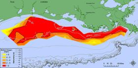
Scientists have determined this year’s Gulf of Mexico “dead zone,” an area of low oxygen that can kill fish and marine life, is 8,776 square miles, an area about the size of New Jersey. It is the largest measured since dead zone mapping began there in 1985.
The measured size is close to the 8,185 square miles forecast by NOAA in June.
The annual forecast, generated from a suite of NOAA-sponsored models, is based on nutrient runoff data from the U.S. Geological Survey. Both NOAA’s June forecast and the actual size show the role of Mississippi River nutrient runoff in determining the size of the dead zone.
This large dead zone size shows that nutrient pollution, primarily from agriculture and developed land runoff in the Mississippi River watershed is continuing to affect the nation’s coastal resources and habitats in the Gulf.
These nutrients stimulate massive algal growth that eventually decomposes, which uses up the oxygen needed to support life in the Gulf. This loss of oxygen can cause the loss of fish habitat or force them to move to other areas to survive, decreased reproductive capabilities in fish species and a reduction in the average size of shrimp caught.
Continue reading at NOAA
Image coutersy of LSU/LUMCON


