NASA’s Aqua satellite provided an infrared look at the newly formed Tropical Depression 16W in the Philippine Sea. 16W is known locally in the Philippines as "Jolina."
NASA’s Aqua satellite provided an infrared look at the newly formed Tropical Depression 16W in the Philippine Sea. 16W is known locally in the Philippines as "Jolina."
In the Philippines, public storm warning signal #1 was placed in effect for the Luzon provinces of Southern Cagayan, Isabela, and Northern Aurora.
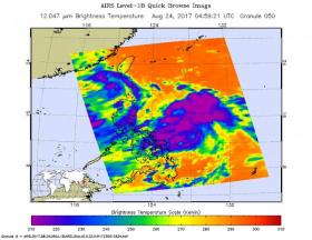
The Atmospheric Infrared Sounder or AIRS instrument aboard NASA's Aqua satellite looked at cloud top temperatures in Tropical Depression 16W using infrared light. The AIRS data were taken on August 24 at 12:59 a.m. EDT (0459 UTC). The image showed some very cold cloud top temperatures as cold as minus 63 degrees Fahrenheit (minus 53 degrees Celsius). NASA research has shown that storms with cloud tops that cold are high up in the troposphere and can generate heavy rainfall.
The infrared data was false-colored at NASA's Jet Propulsion Laboratory in Pasadena, California, where AIRS data is managed.
Read more at NASA/Goddard Space Flight Center
Image: NASA's Aqua satellite captured infrared temperature data on Tropical Depression 16W on August 24 at 12:59 a.m. EDT (0459 UTC). The image showed some very cold cloud top temperatures as cold as minus 63 degrees Fahrenheit (minus 53 degrees Celsius). (Credit: NASA JPL/Ed Olsen)


