At NASA's Goddard Space Flight Center in Greenbelt, Maryland, an analysis of Hurricane Harvey's tremendous rainfall was created using eight days of satellite data.
NASA's Integrated Multi-satellitE Retrievals for GPM or IMERG product is used to make estimates of precipitation from a combination of space-borne passive microwave sensors, including the GMI microwave sensor onboard the Global Precipitation Measurement satellite GPM core satellite, and geostationary IR (infrared) data.
IMERG rainfall estimates for the period 21 to 28 August 2017 showed the accumulated effects of all of the rain from Harvey to date. So far, IMERG shows rainfall totals have reached on the order of 20 inches from the coast near Galveston Bay to in and around the Houston area as a result of the near continuous stream of showers and rain being drawn over the coast in rainbands on the eastern side of Harvey's counter clockwise cyclonic circulation. Elsewhere, at least 10 inches were calculated to have fallen from western Louisiana all the way to near Corpus Christi on the coast.
Continue reading at NASA / Goddard Space Flight Center
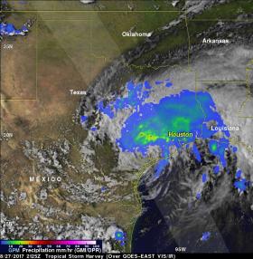
Image: GPM saw Harvey's rainfall pattern was highly asymmetric with the bulk of the rain located north and east of the center on Aug. 27. A broad area of moderate rain (green areas) can be seen stretching from near Galveston Bay to north of Houston and back well to the west. Within this are embedded areas of heavy rain (red areas); the peak estimated rain rate from GPM at the time of this overpass was 96 mm/hour (~3.77 inches per hour). Credits: NASA / JAXA, Hal Pierce


