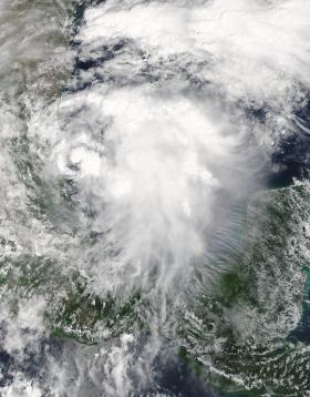
NASA’s Terra satellite passed over Tropical Storm Katia as it was developing along Mexico’s east coast. On Sept. 5, the thirteenth tropical depression of the Eastern Pacific Ocean hurricane season formed about 80 miles (125 kph) east of Tampico, Mexico, in the western Gulf of Mexico.
The Moderate Resolution Imaging Spectroradiometer or MODIS instrument that flies aboard NASA’s Terra satellite captured a visible-light image of the depression as it was organizing on Sept. 5 at 1:10 p.m. EDT (1710 UTC). The image showed that deep convection and thunderstorms were forming over the center. By 4 p.m. EDT, the National Hurricane Center noted that the depression had formed.
At 10 a.m. CDT (1500 UTC), the center of Tropical Storm Katia was located near 21.7 degrees north latitude and 95.9 degrees west longitude. Katia was moving slowly toward the east-southeast near 5 mph (7 kph), and little motion is expected during the next day or so. Maximum sustained winds are near 45 mph (75 kph) with higher gusts. Strengthening is forecast and Katia could become a hurricane before it approaches the coast of Veracruz in a couple of days. The estimated minimum central pressure is 1004 millibars.
Continue reading at NASA / Goddard Space Flight Center
Image: NASA’s Terra satellite passed over developing Tropical Storm Katia in the western Gulf of Mexico on Sept. 5 at 1:10 p.m. EDT (1710 UTC) located off the east coast of Mexico.
Credits: NASA Goddard MODIS Rapid Response Team


