NASA's Aqua satellite captured clear view of the eye of Hurricane Jose at it moved toward the Leeward Islands and strengthened into a Category 4 Hurricane on the Saffir-Simpson Hurricane Wind Scale. Aqua also analyzed the storm in infrared light showing powerful storms around the center, capable of heavy rainfall.
NASA's Aqua satellite captured clear view of the eye of Hurricane Jose at it moved toward the Leeward Islands and strengthened into a Category 4 Hurricane on the Saffir-Simpson Hurricane Wind Scale. Aqua also analyzed the storm in infrared light showing powerful storms around the center, capable of heavy rainfall.
On Sept. 8, the National Hurricane Center posted a Hurricane Watch for Antigua, Barbuda, and Anguilla, Saint Maarten, St. Martin and St. Barthelemy. A Tropical Storm Warning is in effect for Antigua, Barbuda, and Anguilla, and a Tropical Storm Watch is in effect for Montserrat, St Kitts, and Nevis, Saba and St. Eustatius.
The Atmospheric Infrared Sounder or AIRS instrument aboard NASA's Aqua satellite captured infrared temperature data on Hurricane Jose on Sept. 8 at 12:53 a.m. EDT (0453 UTC). The image showed some very cold cloud top temperatures as cold as minus 63 degrees Fahrenheit (minus 53 degrees Celsius) around the center of circulation and in a feeder band of thunderstorms west of the center. NASA research has shown that cloud tops that cold are high in the troposphere and have the potential to generate heavy rainfall.
Continue reading at NASA / Goddard Space Flight Center
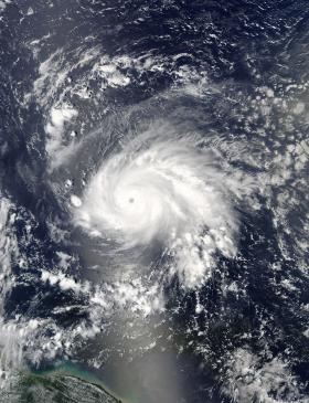
Image: On Sept. 7 at 12:45 p.m. EDT (1645 UTC) the Moderate Resolution Imaging Spectroradiometer or MODIS instrument aboard NASA's Aqua satellite captured a visible-light image of Hurricane Jose approaching the Leeward Islands.
Credits: NASA Goddard MODIS Rapid Response Team


