NASA-NOAA's Suomi NPP satellite captured night-time look at Hurricane Irma as it weakened to a large tropical storm and the GOES East satellite provided a daytime view as the large storm continued moving north over Florida.
NASA-NOAA's Suomi NPP satellite captured night-time look at Hurricane Irma as it weakened to a large tropical storm and the GOES East satellite provided a daytime view as the large storm continued moving north over Florida.
Irma made landfall twice on Sept. 10, first in the Florida Keys and then near Naples. The storm has now been downgraded to a tropical storm but could still cause significant impacts over Georgia and Alabama. NASA's Marshall Space Flight Center in Huntsville, Alabama was under a Tropical Storm Watch on Sept. 11.
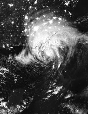
At 3:21 a.m. EDT (0721 UTC), Sept. 11, the Visible Infrared Imaging Radiometer Suite (VIIRS) instrument aboard NASA-NOAA's Suomi NPP satellite provided an night-time infrared image of Irma. The VIIRS image showed the large extent of Irma over Florida, Georgia, Alabama and the Carolinas.
After sunrise, NOAA's GOES East satellite provided a daytime look at Tropical Storm Irma as it continued to move north up the Florida Peninsula. The large storm covered a large area in the southeastern U.S. The image was created by the NASA/NOAA GOES Project at NASA's Goddard Space Flight Center in Greenbelt, Maryland. Irma remains a large tropical cyclone.
Read more at NASA/Goddard Space Flight Center
Image: NASA-NOAA's Suomi NPP satellite captured this night-time infrared image of Hurricane Imra on Sept. 11, 2017, at 3:21 a.m. EDT (0721 UTC) located over central Florida. (Credit: NOAA/NASA Goddard Rapid Response Team)


