Satellite data is enabling forecasters to look inside and outside of powerful Hurricane Maria. A NASA animation of satellite imagery shows Hurricane Maria's first landfall on the island of Dominica. NASA's GPM satellite provided a 3-D look at the storms within that gave forecasters a clue to Maria strengthening into a Category 5 storm, and NASA's Aqua satellite gathered temperature data on the frigid cloud tops of the storm.
Satellite data is enabling forecasters to look inside and outside of powerful Hurricane Maria. A NASA animation of satellite imagery shows Hurricane Maria's first landfall on the island of Dominica. NASA's GPM satellite provided a 3-D look at the storms within that gave forecasters a clue to Maria strengthening into a Category 5 storm, and NASA's Aqua satellite gathered temperature data on the frigid cloud tops of the storm.
Maria's First Landfall
On Monday, Sept. 18 at 9:35 p.m. AST/EDT the National Hurricane Center reported that Maria made landfall on Dominica as a category 5 hurricane. Radar data from Martinique and Air Force Reserve Hurricane Hunter aircraft reports indicated that Maria made landfall on Dominica around 9:15 p.m. AST/EDT (0115 UTC) with estimated winds of 160 mph (260 kph). Dominica is an island in the Caribbean Sea that has mountainous terrain, natural hot springs and tropical rainforests.
NASA Puts Maria's Past Track in Motion
An animation of NOAA's GOES East satellite imagery from Sept. 15 at 7:45 a.m. EDT (1145 UTC) to Sept. 19 ending at 4:45 a.m. EDT (0845 UTC) showed Hurricane Jose moving north along the U.S. East coast and Hurricane Maria move through the Leeward Islands and strengthen to a Category 5 hurricane. The animation shows Maria's landfall in Domenica. The imagery revealed a clear, cloudless eye.
Read more at NASA/Goddard Space Flight Center
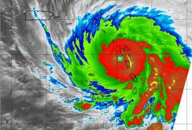
Image: This infrared image of Hurricane Maria's frigid cloud top temperatures was captured by the MODIS instrument aboard NASA's Aqua satellite on Sept. 19 at 2:15 a.m. EDT (0615 UTC) as it moved through the Leeward Islands. (Credit: NASA/NRL)


