Tropical Storm Jose continued to spin south of Massachusetts when NASA's Aqua satellite flew overhead from space and captured an image of the large storm that hasn't moved much.
Tropical Storm Jose continued to spin south of Massachusetts when NASA's Aqua satellite flew overhead from space and captured an image of the large storm that hasn't moved much.
Because of Jose's close proximity to southern New England, the National Hurricane Center said that tropical storm conditions are occurring over portions of southeastern New England, today, Sept. 21. Also, high surf and rip currents expected to continue on the east coast of the United States.
A Tropical Storm Warning is in effect from Woods Hole to Sagamore Beach, including Cape Cod, Massachusetts. In addition to Block Island, Martha's Vineyard and Nantucket.
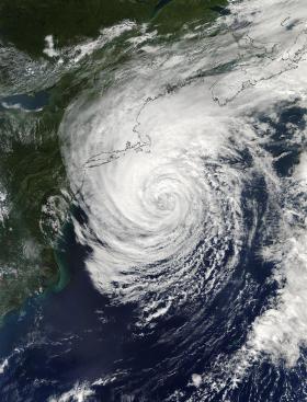
NASA's Aqua satellite flew over Tropical Storm Jose on Sept. 20 at 2 p.m. EDT (1800 UTC) when it was centered south of Cape Cod, Massachusetts. The Moderate Resolution Imaging Spectroradiometer, known as MODIS captured a visible light picture of the large tropical storm. The storm appeared to have a defined center of circulation. Visible and microwave satellite data showed that the storm was still producing well-defined convective bands on the north side of the circulation. Some of these outer bands were approaching the southern New England coastline.
Read more at NASA/Goddard Space Flight Center
Image: On Sept. 21 at 3:30 a.m. EDT (0730 UTC) NASA-NOAA's Suomi NPP looked at Tropical Storm Jose in infrared light and found the coldest cloud tops and most powerful storms were located northwest of the center. (Credit: NASA/NOAA/NRL)


