Tropical Storm Pilar formed near the southwestern coast of Mexico on Saturday, Sept. 23 and continued hugging the coast when NASA's Terra and Aqua satellites passed overhead. Pilar weakened to a tropical depression during the late morning on Sept. 25.
Tropical Storm Pilar formed near the southwestern coast of Mexico on Saturday, Sept. 23 and continued hugging the coast when NASA's Terra and Aqua satellites passed overhead. Pilar weakened to a tropical depression during the late morning on Sept. 25.
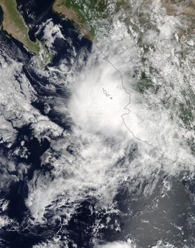
The Moderate Resolution Imaging Spectroradiometer or MODIS instrument that flies aboard NASA's Terra satellite captured a visible picture of Tropical Storm Pilar on Sept. 24 at 1:40 p.m. EDT (1740 UTC). At the time Pilar's center was just off the coast of southwestern Mexico and the storm's clouds and showers extended over the Mexican states of Jalisco, western Zacatecas, southern Sinaloa and southern Durango.
Read more at NASA / Goddard Space Flight Center
Image: The MODIS instrument that flies aboard NASA's Terra satellite captured a visible picture of Tropical Storm Pilar on Sept. 24 at 1:40 p.m. EDT (1740 UTC). At the time Pilar's center was just off the coast of southwestern Mexico.
Credits: NASA Goddard MODIS Rapid Response Team


