NASA-NOAA's Suomi NPP satellite analyzed the temperatures in Post-tropical cyclone Nate's cloud tops as the storm moved over the Ohio Valley. Satellite imagery showed the storm was bringing rainfall from the northeastern U.S., to the Mid-Atlantic and south through the Appalachian Mountains.
NASA-NOAA's Suomi NPP satellite analyzed the temperatures in Post-tropical cyclone Nate's cloud tops as the storm moved over the Ohio Valley. Satellite imagery showed the storm was bringing rainfall from the northeastern U.S., to the Mid-Atlantic and south through the Appalachian Mountains.
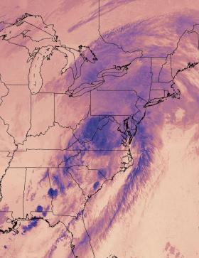
Infrared light provides valuable temperature data to forecasters and cloud top temperatures give clues about highest, coldest, strongest storms within a hurricane. NASA-NOAA's Suomi NPP satellite provided that data and showed the location of the strongest storms in Post-tropical cyclone Nate.
On Oct. 9 at 2:54 a.m. EDT (0654 UTC) the VIIRS instrument aboard NASA-NOAA's Suomi NPP satellite captured a thermal image of cloud top temperatures from the remnants of Nate's cloud tops as it brought rain to the Mid-Atlantic and New England. Coldest cloud top temperatures were seen in storms over the Mid-Atlantic States down the chain of the Appalachian Mountains and back toward the Florida panhandle.
At 5 a.m. EDT (0900 UTC) on Monday, Oct, 9 the center of post-tropical cyclone Nate was located near 40.7 degrees north latitude and 81.7 degrees west longitude. That puts the center of circulation about 20 miles (35 km) southwest of Akron, Ohio.
Read more at NASA/Goddard Space Flight Center
Image: On Oct. 9 at 2:54 a.m. EDT (0654 UTC), NASA-NOAA's Suomi NPP satellite captured this thermal image of cloud top temperatures from the remnants of Nate's cloud tops as it moved into the Mid-Atlantic and New England. (Credit: NOAA/NASA Goddard Rapid Response Team)


