Until recently, glaciers in the United States have been measured in two ways: placing stakes in the snow, as federal scientists have done each year since 1957 at South Cascade Glacier in Washington state; or tracking glacier area using photographs from airplanes and satellites.
Until recently, glaciers in the United States have been measured in two ways: placing stakes in the snow, as federal scientists have done each year since 1957 at South Cascade Glacier in Washington state; or tracking glacier area using photographs from airplanes and satellites.
We now have a third, much more powerful tool. While he was a doctoral student in University of Washington’s Department of Earth and Space Sciences, David Shean devised new ways to use high-resolution satellite images to track elevation changes for massive ice sheets in Antarctica and Greenland. Over the years he wondered: Why aren’t we doing this for mountain glaciers in the United States, like the one visible from his department’s office window?
He has now made that a reality. In 2012, he first asked for satellite time to turn digital eyes on glaciers in the continental U.S., and he has since collected enough data to analyze mass loss for Mount Rainier and almost all the glaciers in the lower 48 states. He will present results from these efforts Oct. 22 at the Geological Society of America’s annual meeting in Seattle.
Continue reading at University of Washington
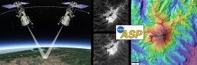
Image: The mapping technique uses a satellite to capture high-resolution images of a specific area from two angles. Then, the NASA Ames Stereo Pipeline software creates an elevation map with accuracy of a few feet. This example shows Mount Baker.
Image Credit: David Shean / University of Washington / DigitalGlobe / NextView License


