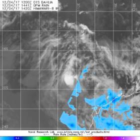
Tropical Depression Dahlia was weakening into a remnant low pressure area when the Global Precipitation Measurement mission core satellite or GPM analyzed the storm's precipitation. GPM found the center devoid of rainfall and light rainfall to the east of center.
Tropical Depression Dahlia was weakening into a remnant low pressure area when the Global Precipitation Measurement mission core satellite or GPM analyzed the storm's precipitation. GPM found the center devoid of rainfall and light rainfall to the east of center.
On Dec. 3 at 4 p.m. EST (2100 UTC) the Joint Typhoon Warning Center issued the final bulletin on Dahlia. At that time, Dahlia was still a tropical storm with maximum sustained winds near 35 knots (40 mph). Dahlia was centered near 16.2 degrees south latitude and 111.9 degrees east longitude. That's about 402 nautical miles north-northwest of Learmonth, Australia. Dahlia was moving to the south at 10 knots (11.5 mph/18.5 kph).
At the time of the last bulletin, infrared satellite imagery showed that the strongest storms were beginning to decouple from the low level circulation center and moving off to the southeast. Early the next day, the storm had become a depression then weakened further to a remnant low pressure area.
Read more at NASA/Goddard Space Flight Center
Image: On Dec 4 at 1441 UTC (9:41 a.m. EST), the GPM core satellite analyzed Tropical Depression Dahlia's rainfall and found the circulation center devoid of precipitation. Light rainfall near 0.1 inches per hour was falling east of the center (light blue). (Credits: NRL/NASA/JAXA)


